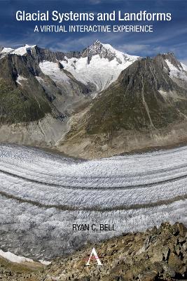
This interactive guide serves to make glacial systems and landforms more accessible, as students use Google Earth and other satellite imagery to understand the patterns and processes found within glacial environments. Guided inquiry activities range from calculating the Mendenhall Glacier’s rate of melting to identifying erosional landforms in the Swiss Alps. In this way, the guide offers a virtual interactive experience in which students can visit and explore glacial systems and landforms in 3D. Through studying these images the student will not only start to recognize the forms commonly found within glacial landscapes, but also develop skills in map analysis and interpretation.
 Kids will love this hilarious fairy tale adventure packed with clever twists, familiar characters and page-turning fun.
 The second book in a fabulous new magical, middle-grade series filled with adventure, wonder and wildness,
This is Book 1 in the Anthem Learning Geography Series. See all Anthem Learning Geography books here.
See More Educational: Geography
No one has written a review for 'Glacial Systems and Landforms: A Virtual Interactive Experience'
Why not be the first to share your opinion?